


Interactive Geography for Schools with iSandBOX | UTS
September 11, 2026
September 14, 2026 at 10:14 AM
Explore how iSandBOX helps children learn about mountains, rivers, valleys and landforms through hands-on interactive geography activities.

Geography You Can Touch: Exploring Mountains, Rivers and Landforms with iSandBOX
Discover how iSandBOX can help schools and kindergartens introduce children to mountains, rivers, valleys and other landforms through hands-on interactive learning.
Geography can be difficult for young children when it exists only in textbooks, maps and pictures. Concepts such as mountains, valleys, slopes, riverbeds and elevation may sound simple, but they describe three-dimensional landscapes that children cannot always easily imagine from a flat page.
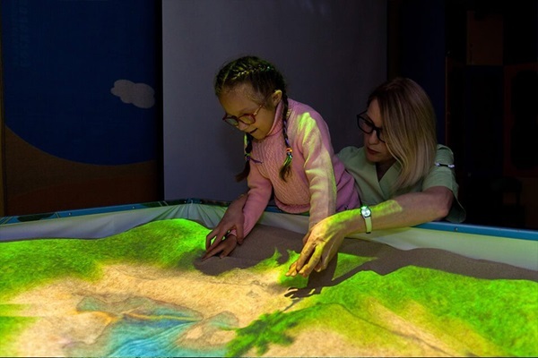
With UTS iSandBOX, geography becomes something children can build, change and explore with their own hands.
Instead of only looking at a picture of a mountain, children can shape one in the sand. They can create a valley next to it, make a depression, form a river channel or completely reshape the landscape. As the surface changes, the interactive visualization helps children see the relationship between the physical shape of the terrain and the geographical features they are learning about.
This turns a traditional geography lesson into an experiment.
From a Flat Map to a Landscape Children Can Explore
For young learners, the idea of relief is much easier to understand when they can physically create it.
A teacher can begin with a simple question:
What makes a mountain a mountain?
Children can build a high area of sand and compare it with the lower land around it. From there, the teacher can introduce basic geographical vocabulary:
mountain;
hill;
peak;
slope;
valley;
plain;
depression;
riverbed.
The children are not simply memorizing definitions. They are connecting each word with a landscape they have created themselves.
For example, after building two mountains, children can remove some sand between them and observe the valley that appears. They can make one side of a mountain steeper than the other and discuss the difference between gentle and steep slopes.
Every change becomes an opportunity for observation and conversation.
Understanding Height and Relief Through Hands-On Learning
One of the most important ideas in physical geography is that the Earth's surface is not flat.
Different areas have different elevations, and these differences create the landscapes we see around us.
With iSandBOX, children can experiment with height directly. They can add sand to create higher terrain or move it away to create lower areas.
A teacher can ask:
Which part of our landscape is the highest?
Where is the lowest point?
What happens if we make this mountain higher?
Can you create a flat plain next to the mountains?
Questions like these encourage children to compare different areas of the landscape rather than simply follow instructions.
They begin to understand geography as a system of relationships: high and low, steep and gentle, mountain and valley, land and water.
Exploring How Rivers Follow the Landscape
Rivers provide another useful topic for an interactive geography lesson.
Before creating a river, the teacher can ask children to predict where water would naturally move through the landscape they have built.
Would it travel over the highest point of a mountain?
Would it move toward lower areas?
Where could a river valley form?
Children can then modify the sand to create channels, slopes and depressions and discuss how the terrain influences the direction of water.
This introduces an important geographical principle: water and relief are closely connected.
The activity can also lead to conversations about real landscapes. Teachers can show children photographs of rivers, mountain valleys or plains and ask them to recreate similar features in iSandBOX.
Change the Landscape — Then Discuss What Happened
One of the strongest educational possibilities of an interactive sandbox is that the landscape does not have to remain unchanged.
Children can experiment.
A teacher might begin with a landscape containing a mountain, valley and river. Then the class can change one element at a time.
What happens if we make the mountain lower?
What if we create a new hill here?
What if we deepen this valley?
What if we block the existing river channel?
Instead of telling children the answer immediately, the teacher can invite them to make a prediction first.
The children modify the landscape, observe the result and compare it with their prediction.
This simple sequence —
predict → change → observe → discuss — transforms the activity from passive demonstration into inquiry-based learning.
A Geography Activity for Small Groups
iSandBOX can also be used for collaborative geography tasks.
For example, a teacher can divide children into small groups and give them a challenge:
Create an island with one mountain, two hills, a valley and a river.
Each child can be responsible for a different part of the landscape. When the model is finished, the group can present it to the class and explain what they created.
For younger children, the task can be simpler:
Build the highest mountain you can.
Make a valley between two hills.
Create a flat area for a town.
For older primary school students, teachers can introduce more complex geographical concepts and ask students to explain why particular features appear where they do.
The same equipment can therefore support activities of different difficulty levels.
Connecting Geography with Other Subjects
A lesson built around a physical landscape does not have to remain limited to geography.
Teachers can connect the activity with other areas of learning.
In science, children can discuss water, erosion, soil and natural processes.
In mathematics, they can compare heights, distances and relative sizes.
In language lessons, children can describe the landscape using new vocabulary or create a story about an expedition through the mountains.
In environmental education, teachers can discuss how landscapes influence ecosystems, settlements and human activity.
This makes iSandBOX suitable for interdisciplinary activities where one interactive environment supports several learning objectives.
Suitable for Schools and Kindergartens
For kindergartens and younger primary school pupils, geography begins with very basic spatial concepts: high and low, near and far, land and water, hill and valley.
Hands-on activities can make these ideas easier to understand because children can see and physically manipulate what they are discussing.
For older pupils, the same environment can become a starting point for learning about relief, watersheds, river systems, elevation and landscape formation.
The teacher determines the complexity of the activity and the vocabulary used.
As a result, iSandBOX can support both guided activities for preschool children and more structured geography lessons in schools.
Geography Becomes an Experience
Children often remember concepts better when they have actively explored them.
With iSandBOX, a mountain is no longer only a shape on a map. It is something a child has built.
A valley is not simply a definition. It is the space they created between higher areas.
A river is not just a blue line in a textbook. It becomes part of a landscape whose shape children can investigate and change.
By combining physical interaction, visual feedback and teacher-led discussion, iSandBOX can turn geography into an activity based on exploration and discovery.
Children do not simply learn what landscapes look like.
They build them, change them and discover how they work.